Log in
All resources
Create a design
Tools
1,787 Free Images of French Language Maps
bibliothèque nationale de france
maps from gallica
guides joanne
atlas minor gerardi mercatoris (1614, maps)
carte des environs de paris (1678)
map of l'evesché du mans by jaillot and cordier
sanson map of the german empire (17th century)
sanson maps of the circles of germany
map of europe by guillaume sanson (1674)
guillaume sanson
atlas minor gerardi mercatoris (1614, maps)
maps of barbary coast by mercator-hondius
maps by louis brion de la tour
1775 maps of asia
maps of the iberian peninsula by mercator-hondius
atlas minor gerardi mercatoris (1614, maps)
atlas minor gerardi mercatoris (1614, maps)
maps of portugal by fernando álvares seco
atlas minor gerardi mercatoris (1614, maps)
maps of mexico by mercator-hondius
atlas minor gerardi mercatoris (1614, maps)
maps of africa by mercator-hondius
1670s maps of rhineland-palatinate
maps of vangiones by sanson
atlas minor gerardi mercatoris (1614, maps)
maps of virginia by mercator-hondius
atlas minor gerardi mercatoris (1614, maps)
maps of morocco by mercator-hondius
maps of biscay and gipuzkoa by mercator-hondius
atlas minor gerardi mercatoris (1614, maps)
maps by pieter mortier
maps from gallica
map of the circle of lower saxony by sanson
bibliothèque nationale de france
antoine-françois tardieu
maps from gallica
map of the upper rhenian circle by sanson
1670s maps of hesse
17th-century maps of the strait of magellan
1668 maps of south america
1698 map of evesché de meaux
robert cordier (engraver)
maps by guillaume sanson
old maps of friesland
maps from gallica
guides joanne
pieter verbiest (ii)
maps from gallica
map of l'evesché du mans by jaillot and cordier
bibliothèque nationale de france
bibliothèque nationale de france
1667 sanson map of africa
maps from gallica
guides joanne
map of l'evesché du mans by jaillot and cordier
bibliothèque nationale de france
maps from gallica
guides joanne
maps from gallica
guides joanne
maps from gallica
guides joanne
bibliothèque nationale de france
cartouches by sanson family
map of l'evesché du mans by jaillot and cordier
bibliothèque nationale de france
l'espagne divisée by guillaume sanson
1690s maps of the iberian peninsula
map of l'evesché du mans by jaillot and cordier
bibliothèque nationale de france
map of the upper rhenian circle by sanson
1700s maps of north rhine-westphalia
géographie générale; physique, politique et économique (1876)
1870s maps of australia
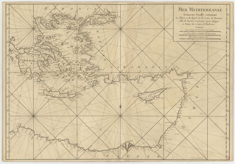
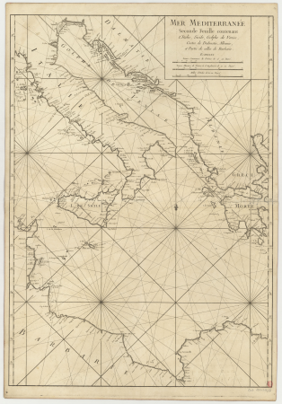
carte de la mer méditerranée en trois feuilles (dheulland et al.)
18th-century maps of the eastern mediterranean
maps of enkhuizen by braun & hogenberg
bibliothèque nationale de france
maps by willem and johannes blaeu
17th-century maps of dombes
maps of châteaudun by braun & hogenberg
maps of chartres by braun & hogenberg
maps of werden by braun & hogenberg
maps of essen by braun & hogenberg
maps of mons (hainaut) by braun & hogenberg
maps of arras by braun & hogenberg
maps of dordrecht by braun & hogenberg
bibliothèque nationale de france
maps of algiers by braun & hogenberg
bibliothèque nationale de france
maps by alexis-hubert jaillot
old maps of duchy of cleves
sanson map of the german empire (17th century)
sanson maps of the circles of germany
carte du mexique et de la floride by guillaume delisle (1703)
french-language maps of mexico
carte de la mer méditerranée en trois feuilles (dheulland et al.)
18th-century maps of the western mediterranean
carte de la mer méditerranée en trois feuilles (dheulland et al.)
old maps of the central mediterranean
maps of ghent by braun & hogenberg
bibliothèque nationale de france
maps of bruges by braun & hogenberg
bibliothèque nationale de france
maps of antwerp by braun & hogenberg
bibliothèque nationale de france
maps of ancona by braun & hogenberg
bibliothèque nationale de france
maps of aachen by braun & hogenberg
bibliothèque nationale de france
maps of avignon by braun & hogenberg
bibliothèque nationale de france
maps of ancona by braun & hogenberg
bibliothèque nationale de france
amérique méridionale (1748, d'anville)
rococo
sanson map of the german empire (17th century)
sanson maps of the circles of germany
sanson map of the german empire (17th century)
sanson maps of the circles of germany
sanson map of the german empire (17th century)
sanson maps of the circles of germany
maps from gallica
guides joanne
maps of bordeaux by braun & hogenberg
maps of nîmes by braun & hogenberg
walls of olivenza, badajoz
maps of olivenza
sanson maps of north america
island of california
bourbonnais in the 17th century
pierre mariette i
mappe-monde geo-hydrographique (sanson and jaillot, 1674)
bibliothèque nationale de france
map of europe by guillaume sanson (1674)
bibliothèque nationale de france
sanson maps of south america
south america in the 1690s
maps from gallica
guides joanne
antoine-françois tardieu
1800s maps of hispaniola
17th-century maps of paraguay
1668 maps of south america
1690s maps of the caribbean
1690s maps of the americas
maps of alsace by guillaume sanson
1660s maps of baden-württemberg
maps from gallica
guides joanne
map of the circle of lower saxony by sanson
bibliothèque nationale de france
maps from gallica
guides joanne
maps of paris by braun & hogenberg
bibliothèque nationale de france
map of europe by guillaume sanson (1674)
bibliothèque nationale de france
map of the circle of upper saxony by sanson
bibliothèque nationale de france
bibliothèque nationale de france
guillaume sanson
carte de france instructive et amusante divisée en quatrevingt six départements - btv1b84949605
bibliothèque nationale de france
map of europe by guillaume sanson (1674)
bibliothèque nationale de france
carte de france instructive et amusante divisée en quatrevingt six départements - btv1b84949605
bibliothèque nationale de france
maps from gallica
guides joanne
map of europe by guillaume sanson (1674)
bibliothèque nationale de france
17th-century maps of africa
maps from gallica
map of the circle of austria by sanson
1700s maps of austria
carte particulière des postes de france dediée au roy par son très humble, tres-obéssant, tres-fidele sujet et serviteur - hubert jaillot.... 20 petites lieues de france (1 - 1 800 000 environ) - btv1b8492995r
bibliothèque nationale de france
carte des environs de paris (1678)
bibliothèque nationale de france
carte des environs de paris (1678)
bibliothèque nationale de france
carte des environs de paris (1678)
bibliothèque nationale de france
map of the circle of bavaria by sanson
bibliothèque nationale de france
old maps of vardø
guillaume sanson
old maps of vardø
guillaume sanson
le royaume de france distingué by guillaume sanson
1724 maps of france
map of the circle of franconia by sanson
1680s maps of bavaria
maps from gallica
guides joanne
charles william meredith van de velde
eran laor cartographic collection
1760 maps of asia
baroque painting
old maps of haarlem
mannerism
carte des environs de paris (1678)
bibliothèque nationale de france
carte des environs de paris (1678)
bibliothèque nationale de france
carte des environs de paris (1678)
bibliothèque nationale de france
carte particulière des postes de france dediée au roy par son très humble, tres-obéssant, tres-fidele sujet et serviteur - hubert jaillot.... 20 petites lieues de france (1 - 1 800 000 environ) - btv1b8492995r
bibliothèque nationale de france
901 - 1000 of 1,787
Next page
/ 18


![Map of Finland / drawn up by P. Lapie, cap[itaine], ing[ieur], geog[raphe]; engraved by Tardieu aïné; written by Giraldon, 1808](https://cdn.creazilla.com/illustrations/10001359680/map-of-finland-drawn-up-by-p-lapie-capitaine-ingieur-geographe-engraved-by-tardieu-an-written-by-giraldon-1808-md.jpg)


![Joanne Guides. Surroundings of Plombières. Scale 10 km. [= Om. 066; 1: 150 000]. L. Thuillier delt, 1891](https://cdn.creazilla.com/illustrations/10000683074/joanne-guides-surroundings-of-plombi-res-scale-10-km-om-066-1-150-000-l-thuillier-delt-1891-md.jpg)


![Olivença / [A. Coquart Sculp.], Antoine Coquart, 1705](https://cdn.creazilla.com/illustrations/10000286512/olivena-a-coquart-sculp-antoine-coquart-1705-sm.webp)

![Duchy of Bourbonnois / [Pierre Mariette], Pierre Mariette I, 1668](https://cdn.creazilla.com/illustrations/10000233377/duchy-of-bourbonnois-pierre-mariette-pierre-mariette-i-1668-md.jpg)


![Joanne Guide. The Vosges. The Vosges. Scale, 30 kilometers [=Om. 068; 1: 440,000 approx.]. L. Thuillier delt, 1888](https://cdn.creazilla.com/illustrations/10001545562/joanne-guide-the-vosges-the-vosges-scale-30-kilometers-om-068-1-440-000-approx-l-thuillier-delt-1888-sm.jpg)

![Paraguay taken from the most recent reports / by G[uillaume] Sanson, 1668](https://cdn.creazilla.com/illustrations/10000773533/paraguay-taken-from-the-most-recent-reports-by-g-uillaume-sanson-1668-md.jpg)


